dp.9: graupel blanketed with snow dp.10: springtime scenario
Tendency
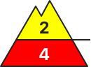
Danger level
1500m
Avalanche Problem
Wind slab
1500m
Persistent weak layer
2500m
Since the early morning the wind has been strong adjacent to ridgelines over a wide area. The sometimes strong wind will transport the old snow. In the course of the day the previously small wind slabs will increase in size once again. As a consequence of a gathering storm force wind from northwesterly directions, large surface-area wind slabs will form since Monday especially adjacent to ridgelines as well as above the tree line. The avalanche prone locations are to be found in particular on wind-loaded slopes of all aspects above approximately 2200 m and at transitions from a shallow to a deep snowpack. The fresh wind slabs are to be found in particular adjacent to ridgelines and in gullies and bowls in all aspects. Over a wide area easily released wind slabs will form. The sometimes large wind slabs can be released easily, even by a single winter sport participant, especially on east to south to west facing aspects above the tree line. This applies in particular at their margins.
Snowpack
dp.9: graupel blanketed with snow dp.10: springtime scenario